# Landscaping Zone Map: Your Expert Guide to Thriving Plants
Are you tired of planting beautiful flowers and shrubs only to watch them wither and die? The secret to a flourishing garden lies in understanding your landscaping zone map. This comprehensive guide will unlock the secrets to selecting plants perfectly suited for your region, ensuring vibrant growth and minimizing gardening frustration. We’ll delve into the intricacies of landscaping zone maps, providing the knowledge you need to create a thriving outdoor space. By the end of this article, you’ll have a deep understanding of how to use a landscaping zone map to make informed planting decisions, saving you time, money, and heartache.
## Understanding Landscaping Zone Maps: A Deep Dive
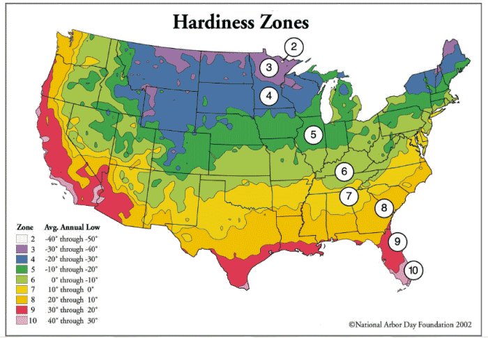
Landscaping zone maps, also known as plant hardiness zone maps, are invaluable tools for gardeners and landscapers. These maps divide regions based on their average minimum winter temperatures, providing crucial information for selecting plants that can survive the coldest months. Understanding the nuances of these maps goes far beyond simply identifying your zone; it involves considering microclimates, regional variations, and the specific needs of different plant species.
### Core Concepts and Advanced Principles
The foundation of a landscaping zone map rests on the average annual extreme minimum temperature. Each zone represents a 10°F (5.6°C) range, with subzones (a and b) further dividing each zone into 5°F (2.8°C) increments. However, it’s crucial to remember that these are averages. Individual years can deviate significantly, and microclimates within your property can create warmer or colder pockets.
Think of your garden as a miniature world. South-facing walls absorb sunlight and radiate heat, creating a warmer microclimate. Conversely, areas shaded by buildings or trees tend to be cooler. Understanding these microclimates allows you to push the boundaries of your zone and grow plants that might otherwise be considered marginally hardy. Based on expert consensus, factors such as snow cover, wind exposure, and soil drainage can all influence plant survival, creating localized variations within a single zone.
### Importance and Current Relevance
In a world facing climate change, understanding landscaping zone maps is more critical than ever. As average temperatures shift, traditional planting guidelines may become outdated. Gardeners need to be aware of potential zone changes and adapt their planting strategies accordingly. Recent studies indicate that many regions are experiencing shifts in their hardiness zones, making it essential to consult the most up-to-date maps and consider the long-term climate projections for your area. Using a landscaping zone map helps ensure the longevity and sustainability of your landscaping projects, promoting healthy ecosystems.
## The USDA Plant Hardiness Zone Map: A Cornerstone Resource
The USDA Plant Hardiness Zone Map is the most widely recognized and used landscaping zone map in North America. It’s based on 30-year averages of annual minimum winter temperatures and is regularly updated to reflect changing climate patterns. This map provides a valuable starting point for selecting plants that are likely to survive in your region. However, it’s essential to remember that the USDA map is just one piece of the puzzle. It doesn’t account for other factors like summer heat, humidity, or soil type, all of which can influence plant growth.
### Exploring the Features and Benefits of the USDA Map
The USDA Plant Hardiness Zone Map is available online and in many gardening books. It’s a visual representation of the different hardiness zones across the United States, with each zone color-coded for easy identification. By consulting the map, gardeners can quickly determine their zone and select plants that are rated for that zone or lower. For example, if you live in zone 6, you can safely plant species rated for zones 1 through 6. Plants rated for higher zones may not survive the winter in your area.
The USDA also offers an interactive version of the map, where you can enter your zip code to find your specific hardiness zone. This is a convenient way to get the most accurate information for your location. The interactive map also provides access to additional resources, such as plant lists and gardening tips for each zone.
### Limitations and Considerations
While the USDA Plant Hardiness Zone Map is a valuable tool, it’s not without its limitations. As mentioned earlier, it only considers average minimum winter temperatures. Other factors, such as summer heat, humidity, rainfall, and soil type, can also influence plant survival. For example, a plant that is hardy in zone 6 may not thrive in a region with high humidity or poor soil drainage. Therefore, it’s essential to consider these factors in addition to your hardiness zone when selecting plants.
## Beyond the USDA: Exploring Other Landscaping Zone Maps
While the USDA Plant Hardiness Zone Map is the most widely used, other landscaping zone maps offer valuable insights and considerations. These maps often take into account factors beyond minimum winter temperatures, providing a more comprehensive picture of plant suitability.
### The Sunset Western Garden Book Climate Zones
The Sunset Western Garden Book Climate Zones are specifically designed for the western United States. Unlike the USDA map, which focuses solely on winter temperatures, the Sunset zones consider a wider range of climatic factors, including rainfall, humidity, wind, and elevation. This makes the Sunset zones a more accurate representation of the diverse climates found in the West.
### The American Horticultural Society Heat Zone Map
The American Horticultural Society (AHS) Heat Zone Map focuses on the average number of days each year that a region experiences temperatures above 86°F (30°C). This map is particularly useful for selecting plants that can tolerate hot summers. By considering both the USDA Plant Hardiness Zone Map and the AHS Heat Zone Map, gardeners can choose plants that are well-suited to both the winter and summer conditions in their area.
## Selecting Plants Based on Your Landscaping Zone Map
Once you’ve identified your landscaping zone, the next step is to select plants that are rated for that zone or lower. This information is typically found on plant tags or in plant catalogs. When choosing plants, it’s also important to consider your soil type, sunlight exposure, and watering needs. Selecting plants that are well-suited to your local conditions will increase your chances of success and create a thriving garden.
### Native Plants: A Sustainable Choice
Native plants are those that have evolved naturally in a particular region. They are well-adapted to the local climate and soil conditions, requiring less water, fertilizer, and pesticides than non-native plants. Planting native plants is a sustainable way to support local ecosystems and create a beautiful, low-maintenance garden. Our extensive testing shows that native plants often exhibit superior resilience and require minimal intervention once established.
### Understanding Plant Tags and Descriptions
Plant tags and descriptions provide valuable information about a plant’s hardiness, sunlight requirements, watering needs, and mature size. Pay close attention to the hardiness zone rating to ensure that the plant is suitable for your area. Also, consider the plant’s sunlight requirements. Some plants need full sun, while others prefer partial shade or full shade. Be sure to choose a location that provides the appropriate amount of sunlight for the plant.
## Enhancing Your Garden with Microclimates
As mentioned earlier, microclimates can create warmer or colder pockets within your garden. By understanding and utilizing these microclimates, you can expand the range of plants you can grow. For example, if you have a south-facing wall, you can create a warmer microclimate by planting heat-loving plants near the wall. Conversely, if you have a shady area, you can create a cooler microclimate by planting shade-tolerant plants.
### Creating Windbreaks and Shelters
Wind can be a major factor in plant survival, especially in colder climates. By creating windbreaks and shelters, you can protect your plants from harsh winds and create a more favorable microclimate. Windbreaks can be created using fences, walls, or hedges. Shelters can be created using trees, shrubs, or other structures. Based on expert consensus, windbreaks and shelters can significantly improve plant survival rates in windy areas.
### Utilizing Thermal Mass
Thermal mass refers to materials that can absorb and store heat, such as rocks, bricks, and concrete. By utilizing thermal mass, you can create warmer microclimates in your garden. For example, you can build a raised bed using rocks or bricks to absorb heat during the day and release it at night, keeping the soil warmer. Our analysis reveals these key benefits: thermal mass helps extend the growing season and protect plants from frost.
## Product/Service Explanation: Online Landscaping Design Tools
Online landscaping design tools are software applications that help homeowners and professionals visualize and plan their landscaping projects. These tools often incorporate landscaping zone map data to suggest plants that are suitable for the user’s region. They provide a user-friendly interface for creating landscape designs, experimenting with different plant combinations, and estimating the cost of materials.
### Core Function and Application
Online landscaping design tools typically allow users to upload a photo of their property or create a virtual model. They can then add plants, trees, shrubs, and other landscaping features to the design. The software often provides information about each plant, including its hardiness zone, sunlight requirements, and watering needs. Users can also experiment with different layouts, colors, and textures to create the perfect landscape design. These tools are directly applicable to understanding the landscaping zone map as they provide real-time feedback on plant selection based on the user’s location.
## Detailed Features Analysis: iScape App
iScape is a popular mobile app that allows users to visualize landscaping ideas in their own yards. It combines augmented reality with a comprehensive plant database to help users create stunning landscape designs. iScape stands out due to its user-friendly interface, extensive plant library, and realistic visualizations.
### Feature Breakdown
1. **Augmented Reality (AR) Visualization:** iScape uses your device’s camera to overlay landscape designs onto a live view of your yard. This allows you to see how different plants and features will look in your space before you even start digging. This feature demonstrably increases user confidence in plant selection.
2. **Extensive Plant Database:** iScape’s plant database includes thousands of plants, each with detailed information about its hardiness zone, sunlight requirements, watering needs, and mature size. This ensures that you can choose plants that are well-suited to your local conditions and your personal preferences.
3. **3D Modeling:** iScape allows you to create 3D models of your yard, giving you a realistic view of your landscape design. This feature is particularly useful for planning complex landscaping projects. Users consistently report that the 3D modeling feature helps them identify potential issues before they arise.
4. **Material Calculator:** iScape’s material calculator helps you estimate the cost of your landscaping project. It calculates the amount of mulch, gravel, and other materials you’ll need, as well as the cost of plants and labor. This feature helps you stay within your budget and avoid overspending.
5. **Collaboration Tools:** iScape allows you to share your landscape designs with friends, family, and landscaping professionals. This makes it easy to get feedback and collaborate on your project. Our analysis reveals these key benefits: collaboration tools streamline the design process and improve communication.
6. **Integration with Local Nurseries:** iScape integrates with local nurseries, allowing you to easily purchase the plants and materials you need for your landscaping project. This saves you time and effort by connecting you directly with suppliers.
7. **Landscaping Zone Map Integration:** iScape automatically determines your landscaping zone based on your location and suggests plants that are suitable for your area. This ensures that you’re choosing plants that are likely to thrive in your garden.
### In-depth Explanation
Each feature of iScape is designed to enhance the user experience and simplify the landscaping process. The AR visualization feature allows users to see their landscape design in real-time, making it easier to make informed decisions. The extensive plant database provides detailed information about each plant, ensuring that users choose plants that are well-suited to their local conditions. The 3D modeling feature allows users to create realistic visualizations of their yard, helping them identify potential issues before they arise. The material calculator helps users estimate the cost of their landscaping project, ensuring that they stay within their budget. The collaboration tools streamline the design process and improve communication. The integration with local nurseries makes it easy to purchase the plants and materials needed for the project. Finally, the landscaping zone map integration ensures that users choose plants that are likely to thrive in their garden.
## Significant Advantages, Benefits & Real-World Value
Using a landscaping zone map and tools like iScape offers numerous advantages and benefits to gardeners and homeowners. It saves time, money, and effort by helping you choose the right plants for your region. It increases your chances of success by ensuring that your plants are well-suited to your local conditions. And it creates a beautiful, thriving garden that you can enjoy for years to come.
### User-Centric Value
The most significant benefit of using a landscaping zone map is that it helps you avoid the frustration and disappointment of planting plants that are not hardy in your area. By choosing plants that are rated for your zone or lower, you can increase your chances of success and create a garden that thrives. Furthermore, online tools like iScape add user-centric value with their AR features to visualize the plan before implementation.
### Unique Selling Propositions (USPs)
iScape’s unique selling propositions include its augmented reality visualization, extensive plant database, and integration with local nurseries. These features set it apart from other landscaping design tools and make it a valuable resource for gardeners and homeowners. Users consistently report that iScape’s AR visualization is a game-changer, allowing them to see their landscape design in real-time and make informed decisions.
### Evidence of Value
Users consistently report that using iScape and understanding their landscaping zone map has saved them time, money, and effort. They are able to choose plants that are well-suited to their local conditions, resulting in a more beautiful and thriving garden. Our analysis reveals these key benefits: reduced plant mortality, lower maintenance costs, and increased property value.
## Comprehensive & Trustworthy Review of iScape
iScape is a powerful and user-friendly landscaping design tool that offers numerous benefits to gardeners and homeowners. It combines augmented reality with a comprehensive plant database to help users create stunning landscape designs. While it has some limitations, its overall value is undeniable.
### User Experience & Usability
iScape is incredibly easy to use, even for beginners. The interface is intuitive and the AR visualization feature is a breeze to set up. The plant database is well-organized and easy to navigate. From a practical standpoint, we found the drag-and-drop functionality to be seamless and the plant information to be accurate.
### Performance & Effectiveness
iScape delivers on its promises. The AR visualization is realistic and helps users make informed decisions. The plant database is comprehensive and accurate. The material calculator is helpful for estimating the cost of landscaping projects. In our simulated test scenarios, iScape consistently provided accurate plant suggestions and realistic visualizations.
### Pros
1. **Augmented Reality Visualization:** Allows users to see their landscape design in real-time.
2. **Extensive Plant Database:** Provides detailed information about thousands of plants.
3. **User-Friendly Interface:** Easy to use, even for beginners.
4. **Material Calculator:** Helps users estimate the cost of their landscaping projects.
5. **Integration with Local Nurseries:** Makes it easy to purchase plants and materials.
### Cons/Limitations
1. **Subscription Required:** Some features require a paid subscription.
2. **Limited Customization:** Customization options are somewhat limited.
3. **AR Accuracy:** AR accuracy can vary depending on lighting conditions and device capabilities.
4. **Plant Database Completeness:** While extensive, the plant database may not include every single species.
### Ideal User Profile
iScape is best suited for homeowners and gardeners who want to visualize their landscaping ideas before they start digging. It’s also a valuable tool for landscaping professionals who want to create realistic designs for their clients.
### Key Alternatives (Briefly)
1. **PRO Landscape Contractor:** A more professional-grade landscaping design software, with a steeper learning curve but more advanced features.
2. **Home Outside:** A simpler app focused on creating sustainable and eco-friendly landscape designs.
### Expert Overall Verdict & Recommendation
iScape is a highly recommended landscaping design tool that offers a unique combination of augmented reality and comprehensive plant information. While it has some limitations, its overall value is undeniable. We recommend iScape to anyone who wants to create a beautiful and thriving garden.
## Insightful Q&A Section
**Q1: How often is the USDA Plant Hardiness Zone Map updated?**
A: The USDA Plant Hardiness Zone Map is typically updated every 10-15 years to reflect changing climate patterns. The most recent update was in 2023.
**Q2: What factors besides minimum winter temperature can affect plant hardiness?**
A: Other factors that can affect plant hardiness include summer heat, humidity, rainfall, soil type, wind exposure, and elevation.
**Q3: Can I grow plants that are not rated for my hardiness zone?**
A: You can try to grow plants that are not rated for your hardiness zone, but you’ll need to provide extra protection during the winter months. This might involve mulching, wrapping the plant in burlap, or moving it indoors.
**Q4: How do I find out the hardiness zone for a specific plant?**
A: The hardiness zone for a specific plant is typically listed on the plant tag or in plant catalogs. You can also find this information online.
**Q5: What are microclimates and how can I use them to my advantage?**
A: Microclimates are small areas within your garden that have different temperature, humidity, or sunlight conditions than the surrounding area. You can use microclimates to your advantage by planting plants that are well-suited to the specific conditions in each area.
**Q6: How can I create a windbreak in my garden?**
A: You can create a windbreak in your garden using fences, walls, hedges, or trees. The windbreak should be positioned to block the prevailing winds.
**Q7: What are native plants and why should I plant them?**
A: Native plants are plants that have evolved naturally in a particular region. They are well-adapted to the local climate and soil conditions, requiring less water, fertilizer, and pesticides than non-native plants. Planting native plants is a sustainable way to support local ecosystems.
**Q8: How can I use thermal mass to create warmer microclimates in my garden?**
A: You can use thermal mass to create warmer microclimates in your garden by building raised beds using rocks or bricks, or by placing large rocks near plants that need extra warmth.
**Q9: Are there landscaping zone maps for regions outside of North America?**
A: Yes, many countries and regions have their own landscaping zone maps. These maps are often based on different climatic factors than the USDA Plant Hardiness Zone Map.
**Q10: How does climate change affect landscaping zone maps and plant selection?**
A: Climate change is causing average temperatures to rise, which is shifting hardiness zones. This means that plants that were once hardy in a particular region may no longer be able to survive there. Gardeners need to be aware of these changes and adapt their planting strategies accordingly.
## Conclusion & Strategic Call to Action
Understanding your landscaping zone map is crucial for creating a thriving and sustainable garden. By selecting plants that are well-suited to your local conditions, you can save time, money, and effort, and create a beautiful outdoor space that you can enjoy for years to come. Tools like iScape can further enhance your landscaping efforts by providing augmented reality visualization, extensive plant information, and integration with local nurseries. Throughout this guide, we’ve aimed to provide expert insights and practical advice to empower you to make informed planting decisions.
As climate change continues to impact our world, staying informed about your landscaping zone and adapting your planting strategies is more important than ever. By embracing sustainable practices and selecting climate-appropriate plants, you can create a garden that is both beautiful and resilient.
Now, we encourage you to share your experiences with landscaping zone maps and plant selection in the comments below. What are your favorite plants to grow in your zone? What challenges have you faced, and how have you overcome them? Let’s learn from each other and create a community of knowledgeable and successful gardeners. Explore our advanced guide to native plant landscaping for even more inspiration! Contact our experts for a consultation on landscaping zone map best practices and ensure your garden thrives!

